File:Kingdom of Hungary counties-2.svg

From blackwiki
Jump to navigation Jump to search

Original file(SVG file, nominally 779 × 513 pixels, file size: 265 KB)

This file is from Wikimedia Commons and may be used by other projects. The description on its file description page there is shown below.

Description

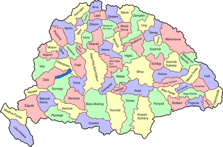
Map of counties of Kingdom of Hungary (Hungary proper and Croatia & Slavonia), 1886-1918.

I have organised this into layers: Three layers of paths for the counties, for the county borders, and for external border. and one layer for the text labels. I have added basic styles and classified all elements. I have given all elements reasonable IDs the counties (the county name) and the borders (the names of the counties on each side) and the text labels (the names of the counties, with underscores indicating where they are split across labels). The counties are classed into four styles to make a four colour map, of course the colours can be changed just by changing the style (there as a fifth style for Lake Balaton, which does not show up very well on tis uploaded one). The main thing now is to fix the text styles.
Date (UTC)
Source
Author
Other versions
File:Kingdom_of_Hungary_location.svg


This is a retouched picture, which means that it has been digitally altered from its original version. Modifications: As described - added more useful metadata and structure. The original can be viewed here: Kingdom of Hungary counties.svg. Modifications made by SimonTrew.

I, the copyright holder of this work, hereby publish it under the following license:
Public domain I, the copyright holder of this work, release this work into the public domain. This applies worldwide.
In some countries this may not be legally possible; if so:
I grant anyone the right to use this work for any purpose, without any conditions, unless such conditions are required by law.

Original upload log

This image is a derivative work of the following images:

  • File:Kingdom_of_Hungary_counties.svg licensed with PD-self
    • 2007-08-20T20:25:30Z Xavax 779x513 (240591 Bytes) == Summary == {{Information| |Description= Map of counties of Hungary with Croatia & Slavonia, 1886-1918 |Source=own drawing |Date=April 30, 2006 |Author=[[User:IMeowbot]] |Permission= |other_versions= }} == Licensing == {{P
    • 2006-04-30T22:10:47Z IMeowbot 779x513 (228524 Bytes) line weight
    • 2006-04-30T21:34:49Z IMeowbot 779x513 (225942 Bytes)
    • 2006-04-30T18:34:30Z IMeowbot 779x513 (199213 Bytes) {{Information| |Description= Map of late 1870s Hungary counties |Source=own drawing |Date=April 30, 2006 |Author=[[User:IMeowbot]] |Permission= |other_versions= }}

Uploaded with derivativeFX

Captions

Add a one-line explanation of what this file represents

Items portrayed in this file

depicts

3 December 2009

File history

Click on a date/time to view the file as it appeared at that time.

Date/TimeThumbnailDimensionsUserComment
current17:57, 5 December 2009Thumbnail for version as of 17:57, 5 December 2009779 × 513 (265 KB)SimonTrewI missed some fixes of Veszprém